THIMPU
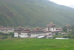 Lying in a valley (elevation 2,350 m), Thimpu is unlike any other capital in the world. The traditional architecture of its houses and buildings is particularly striking. Lying in a valley (elevation 2,350 m), Thimpu is unlike any other capital in the world. The traditional architecture of its houses and buildings is particularly striking.
The places to visit are the Memorial Chorten, dedicated to the late King Jigme Dorji Wangchuk; Tashichho Dzong, seat of the government of Bhutan and the summer residence of the central monk body; the Traditional Medicine Hospital where herbal medicines are prepared; the National Library, a treasure trove of ancient texts; the National Institute for Zorig Chosum for thanka painting, sculpture, wood and slate carving, gold works, embroidery and traditional boot making; Changangkha Lakhang which contains ancient scriptures and thanka paintings; and Simtokha Dzong, Bhutan's oldest fortress which now houses a school for Buddhist studies. You can also visit the smithy on the other side of the Thimpu River to see traditional gold and silver smiths at work, the Folk Heritage Museum , which showcases a typical Bhutanese farmhouse, and the Takin Sanctuary (the takin is the national animal of Bhutan ) above the Motithang area.
Paro
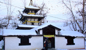
The town of Paro in western Bhutan also attracts tourists with its scenic locales, beautiful landscapes, wooded villages and historic buildings. The Rimpung Dzong or Paro Dzong stands on a hillside above the gently meandering Paro River. The Ta dzong is an ancient watchtower where the National Museum has been housed. The National Museum and the famous Taktshang Monastery are both located here. Kyichu Iyakhang, one of the holiest temples of Bhutan lies 8 km from Paro. The Taktsang (Tiger’s Nest) is a pilgrimage place that every Bhutanese tries to visit at least once in a lifetime.
Wangdi Phodrang (or Wangdi) is situated 70 km (three hours' drive) south-east of Thimpu. The Wangdi Phodrang Dzong played a key role during the unification of Bhutan . En route from Wangdi to Tongsa is the Gangtey Gompa, the biggest Nyingmapa monastery in Bhutan .
CENTRAL BHUTAN
Trongsa is 129 km (four and a half hours' drive) east of Wangdi and crosses the 3,300 m Pelela Pass. The Trongsa Dzong, the ancestral home of Bhutan 's royal family, houses 23 temples. The watchtower, Ta Dzong, has a temple dedicated to King Gesar, the hero of a great epic.
Bumthang consists of the valleys of Chumey, Choekhor, Tang and Ura. It takes two and a half hours to reach Bumthang, 68 km northeast of Trongsa. Bumthang is ideal for making excursions to the many monasteries and shrines - Tharpaling, Choedrak, Tamshing, Kurjey, Jambey, Kunzangdra among others - as well as to Mebartso, "the flaming lake".
Bumthang,
The spiritual heartland of Bhutan, Bumthang, is where the most ancient and precious Buddhist sites are located. It is the home to the most important dzongs, temples and palaces. Wangdichholing Palace, the residence of the former king, Ugyen Wangchuk; the temple of Jambey Lhakang, the sacred cave of Kurjey Lhakang; and the largest Bhutanese dzong, Jakar, are all located here.
Trongsa
Lying in the centre of Bhutan, Trongsa is of great importance in the history of Bhutan. Both His Majesty King Ugyen Wangchuck, who was elected the country's first hereditary monarch, and his successor, King Jigme Wangchuck, ruled the country from Trongsa's ancient dzong. The present King continued this tradition when he was appointed Trongsa Penlop in 1972 shortly before he ascended the throne of Bhutan. Trongsa Dzong is an awe-inspiring and impregnable fortress. It has a labyrinth of temples, corridors and offices holding court over the local community. Trongsa is one of the quaintest and most charming of all Bhutanese towns. Its vista is traditional in appearance with wooden slatted houses lining the side of the hill.
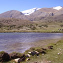
Phobjika is a glacial valley that has been designated a conservation area. It lies on the borders of the Black Mountain National Park that is one of the most important wildlife preserves in Bhutan. The rare, endangered black-necked cranes that have a special place in Bhutanese folklore roost here in the winters. Tourists can view their roosting places with permission from relevant authorities. Barking deer, wild boars, leopards, Himalayan black bears and red foxes are some of the animals that live here. The Satkeng Wildlife Sanctuary is also located nearby. The wild east of the Bhutanese kingdom can be explored from Punakha, Trashigang, Wangdue Phodrang and Gangtey Gompa, which are some of the favorite tourist sites.
One of the most spectacular drives in Bhutan is the 20 km stretch between Sengor and Namning in East Bhutan. Huge cascading waterfalls, endless turns and frequent fogs make for exhilarating travel. Travelers pass citrus groves in the relatively mild climate at Lingmithang, only an hour after being immersed in pine forest, dropping through 6,562 feet of ice and snow.
Mongar : The Kurichu Hydroelectric project is located in Mongar. Arriving in Mongar is welcome respite from the seemingly endless turn of the journey over the pass. The tourist hotel has a lawn and balcony where travelers can take a well earned break. The town is small with a sprinkling of shops. Mongar, like Tashigang further east, is built on the side of a hill instead of next to the river on the valley floor like other towns in the kingdom.
A secondary school is located above the Dzong and is worthwhile visiting. Resembling the large public school in northern India it also offers a splendid view over the surrounding valley.
The present Dzong is modern compared to others in the kingdom. It was built on the orders of the third King, Jigme Dorji Wang chuck. The Kurichu Hydroelectric project will change the industrial emphasis of the Monger area after it is complete before the turn of the millennium. When complete it will have the capacity to output 60 megawatts of hydroelectricity. The Mongar Dzong is modern compared to others in the kingdom.
Tashigang : The road from Mongar passes the Yadi loops. For five miles the road creates figures of eight as it descends to the valley floor.
Arriving in Tashigang is momentous as it mars the end of a 547 kilometer drive from Thimphu. The town, also high up on a Mountain, is busier than any other Bhutanese town. Its proximity to Samdrup Jonkar in the south has enabled it to grow as a centre of commerce.
Tashigang is used as the market place for the hill people from Merak and sakteng wh are remarkable for theier exceptional features and for their cosatumes which is brighty coloured and different from customary Bhutanese clothing.
The 17th Century Dzong is built on top of a cliff on the edge of town. The views from the courtyards of the dzong are wonderful. From the parapets it is easy to see why the dzong was considered to be impregnable from invading armies. Until the recent opening of an administrative center in the dzong at Tshiyangtse, Tashigang was the center of all religious and secular activity for the region.
Tashiyangtse : A few kilometers north of Tashigang, Tashiyangtse Dzong is a half hour walk from the road. The monk body leaves the monastery during the winter for warmer surroundings. A town has developed around Chorten Kora, one of the only two temples built in a style prevalent in Nepal and the spot where Guru Rimpoche is believed to have had a vision that a temple and chorten would be built.
East Bhutan
The driven across the Thumsingla pass and the subsequent descent from high altitude pine forest to lush pastures and orchards is one of the most exciting drives in all of the Himalayas. Gushing waterfalls, steep cliffs with even steeper drops, blazing flowers, and constantly changing vegetation combine to make this journey as varied as it is beautiful.
If the weather is clear the high eastern range of mountains comes into view from the top of the pass and in inclement weather misty mountain views across many peaks can be seen.
Eastern people speak a different dialect to westerners and they often cannot understand each other. The country is a more rugged and the population more sparse. However some of the best trekking can be made in the east of the country.
Certainly the most spectacular drive in Bhutan is the 20 kilometer of road between Sengor and naming on the eastern side of the Thumsingla Pass. Sheer drops of the thousand of metres, huge cascading waterfalls, endless turns and frequent fog from a rise in a temperature make for unnerving but exhilarating travel. After dropping 20000 meters through snow and ice to a relatively mild climate, travelers pass citruss groves only an hour after being immersed in pine forest
The South East and South West Bhutan : The road from Tashigang to Samdrup Jongkhr was completed in the early 1960s and enables the eastern half of the country to access and benefit from trade with the south as well as to cross the Indian border. It is possible to drive from Samdrup Jongkhar to Phuentsholing via the Indian territories of Assam and West Bengal.
There is little for travelers to see in this area but some visitors choose to use Samdrup Jongkhar as a more convenient exit town. The journey from Tashigang passes Pemagatshel, a newly created independent district with its own Dzong. The road descends fairly abruptly through thick jungle before arriving at Samdrup Jongkhar. This town is no more than a frontier post with couple of descent hotels and restaurants to wile away the time when the border is not open.
Phuentsholing in the south west is a bustling border town and can also be used as an exit point from Bhutan.
Wangduphodrang
Wangduphodrang is the last town on the central highway before central Bhutan. The town is no more than an enlarged village with a few well-provided shops.
One hotel with basic facilities is situated behind Wangduphodrang’s square. Siting of the top of the hill looking out over the junction of two rivers, Wangduphodrang Dzong is the tow’s most visible feature. In the 17th century Wangduphodrang played a critical role in unifying the western, central and southern Bhutanese districts.
Situated south of the road and east of Wangduphodrang, Gantey Gompa is an old monastery dating back to the 17th century. The Gompa itself is similar in style to the temples found in many Bhutanese Dzongs. It situation, however, is remarkable. After a difficult south through the mountains, the road from the highway leads to a rare opening into a golden field of maize and yaks. A few kilometers passed the Gompa on the valley floor is the village of Phobjika. This is the winter home of black-necked cranes that migrate from the arid planes in the north to pass the winter in milder and lower climes.
|